Thursday, December 4, 2014

Noctilucent Clouds... Nature's Shy Beauty

Over the South Pole, it is still noctilucent cloud season! Noctilucent clouds (NLCs) there are spreading and brightening. Below is an image taken at the end of November from NASA's AIM spacecraft showing the colorful display over.

Figure 1. Satellite Image over Antarctica taken on November, 27th.
The season for these beauties over the southern hemisphere began on Nov. 22nd with just a few puffy clouds over the frozen continent. NLC's can develop and multiply rapidly once they first appear. If you're unfamiliar on the type of cloud that is foreign to our area of the world, they are truly a beautiful sight. For the best chance of seeing these shy clouds, you need to look high up in the far northern & southern latitudes, usually during dawn and dusk with the aid of the setting/rising sun light display.

So, what are noctilucent clouds? Below is an image showing off one instance of its brilliant display.

Figure 2. Image of noctilucent clouds AFTER sunset. Notice how lit they are, even when the sun is WELL BELOW the horizon.

Noctilucent (meaning night shining in Latin) clouds are composed of tiny ice crystals present as high as clouds can be in Earth's atmosphere (sometimes above 50 miles or ~85 km!). They are the highest cloud group that we have on the planet.

Their domain is over the highest latitudes on Earth. The closer to the poles you travel, the better that chances of seeing them will be. But even traveling north through Canada or hiking through the Andes south along South America will not guarantee a successful sighting of these bashful clouds. They are NORMALLY too faint to be seen. There are only two, pristine times of the day to view them... around dawn and dusk (better time), assuming that the viewable sky is clear enough to look 50+ miles up.

NLC's are unique, in that they are only revealed to the observer (you) when sunlight illuminates them from BELOW THE HORIZON. Fast Fact: This is the only species of cloud that is always better to see when the sun is below the horizon.


Figure 3. Showing how to properly view NLC's. Image courtesy theflatearthsocity.org
Figure 3 shows how you can properly see these clouds. In fact, it all boils down to mathematics. Since these clouds are so high up the elevation scale in the sky... you could be looking well over 100 miles up and out toward the cloud, with the sunlight coming from below the horizon. Very cool!

Happy almost Friday,

Joe

Thursday, November 13, 2014

Snowy, snowy Thursday in Michiana

Thanks for driving safely this morning, everybody. Wow... very winter this morning. We just keep upping the snow total forecast. EVERYTHING came together for Michiana to see moderate to even heavy snow in those lake effect snow bands. The highest official report I can find so far is 4.5" about 2 miles away from Roseland. South Bend likely received about the same.


We'll see even more snowfall with chances of lake effect snow continuing through the morning... through the afternoon... and tonight through about the 1st half of FRIDAY. Before it's all done (and it may not be done until tomorrow afternoon), we should get some hefty accumulations. Keep it safe on the roads. Roads were not close to ready to handle the snow this morning.


-- The Rest --
It'll take about a day to get past that 'initial shock' that the first real snowfall has passed. We don't have much of a break.


Saturday does look dry... still expecting some sunshine with high pressure sliding to the south.


A chance of light, system snow still looks on track for Sunday. Models are trending light snow amounts happening mainly in the morning.


Then next week... oh, next week. It looks active. We'll be looking for another opportune set up fo lake effect snow. Timing right now looks to first happen later MON afternoon. But we have that NW wind flow possibly lasting well into TUE and perhaps even into WED morning. There's frigid air coming in with that NW wind. Highs likely fall into the 20s for Tuesday with morning lows in the teens. Watching for accumulations will be a main focus.


-- GOOD NEWS --
I wanted to end on a positive note. Long term models are still trending warmer and dryer late next week. NEXT Friday may actually get into the 40s!


Stay warm & drive safe,


Joe

Tuesday, November 11, 2014

Detailed Forecast: Tuesday, November 11th... Veterans Day

-- Today --
Here comes the leading edge of the arctic air. Highs in the mid 50s will happen early... until the cold front passes through pretty much right at lunch time. Temperatures will fall fast this afternoon. We go from the mid 40s to near 40 degrees in the matter of just a few hours. Then overnight lows settle in around 27 degrees.

Precip chances are still looking very good. Rain showers look likely from late this morning with chances until the mid afternoon. We may even get a little wintry mix courtesy of some lake effect tonight. But if we see any flakes... they do look to finish up before we drive in to work tomorrow.
 
Veterans Day Forecast Planner
-- Hump Day --

Speaking of tomorrow, it's the first bitterly cold day that will string together in the long term.

High temps settle near freezing... around 32 to 33 degrees. That's it. It looks dry but I will have to mention the dreaded wind chill. With a WNW wind around 10 to 20 mph or so... the 'feel like' temperature will be in the low 20s at times with even wind chills in the teens during the morning. This will be the 1st time we feel that this season... dress warmly.

-- The Rest --
Cold... with chances of snow here-and-there. That's about all we can look for in the long term.

High temps will be in the low to mid 30s all the way through the weekend. Monday may be the COLDEST DAY with another surge of cold air wrapping in from the north. Overnight lows stay in the 20s with a morning or two in the teens not out of the question... especially MON morning.

There will be rounds of snow flurries and snow showers with this cold air outbreak. The next round is Thursday... potentially kick starting early in the morning. That chance will at least until Thursday night but medium range models have chances until FRI morning due to a cold, NW wind flow. Over an inch to even a couple inches of light, lake effect snow are looking likely. This definitely could slow down driving for the AM rush THU through the AM rush FRI. If that's where you drive... plan ahead already.
 
Snowfall forecast WED night Through FRI morning. Courtesy: wxcaster.com


Then a little system snow still looks on par for SUN... then lake effect showers for MON. In terms of total accumulations with all this... it's still too early. But long term models have us in the 1 to 2 inch range if you just need to see the numbers. Winter is upon us! Yay... not really, haha!

Stay warm,

Joe

Monday, November 10, 2014

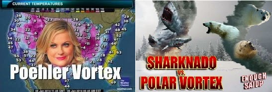
Polar Vortex: Here We Go Again. Bringing Back The Worn-Out, Weather Jargon Cliché.

Oh boy, here we go again. Meteorologists everywhere and certain people on the FOX28 Morning Show are face-palming themselves due to the incorrect use of Polar Vortex... Again... for two seasons in a row. Really???

Two face-palms... One for 2013-14 & the 2nd for This season
 
 There are already plenty of legitimate online resources that you can read on the correct use of this interesting weather term. There are a plethora of them... a myriad some may say. All it takes is your time. And it's worth it! It is an interesting weather phenomena that is a direct result of Eath's atmosphere spinning along Earth's axis. Great stuff!

I will say... a lot of funny memes came out from it last year. I'm hoping for more. It's a guilty pleasure.
2 Of My Favorite Polar Vortex Memes

Alright, let's do some learning. The Polar Vortex is NOT an event. It's not a thing us TV folks came up with to get your attention. It's been studied by climate scientists for decades. It was actually 1st identified in the 1800's.

Courtesy: Mashable.com. Polar Vortex winds depiction.


Strictly speaking, this polar vortex that will dip down into the northern U.S. is the whirl of winds that flows west-to-east and encircles the North Pole over the northern hemisphere (NH). Very simply, the STRONGER these winds run, the COLDER they get, and the more efficient they are at keeping the Arctic-frigid air around the poles.
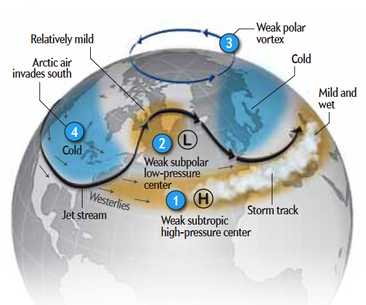
Courtesy: scientificamerican. General upper air patter during a Weak Polar Vortex


But... let's say these strong winds weaken... which they do from time-to-time for various reasons. When winds start to slow down, the vortex starts to waver. This in turn allows the Arctic air to break south and flow (advect) into lower latitudes while also churning warmer air from the south toward the North Pole.

Last winter was classified as a WEAK polar vortex season due to the fact these 'dips' occurred much more frequently. This allowed for a record-cold winter AND in turn resulted in record snowfall due to frequent arctic air outbreaks traveling over an 'open' Lake Michigan... resulting in more frequent lake effect snow events. The unofficial total for South Bend's snowfall last winter was 109.2 inches. Remember, it was unofficial due to missing airport data. Here's a complete look back from the National Weather Service on last winter for SBN & Fort Wayne: http://www.crh.noaa.gov/iwx/?n=2013_2014winter

More things to take out of this: the is not just 'A' polar vortex. There are two forever cyclonically rotating around Earth. They are flowing way high up in the atmosphere... almost completely free of friction to stop it. Our more familiar one over the North Pole and a second over the South Pole. There's also a polar vortex over the north pole of Saturn AND the south pole of Saturn... and Jupiter... and Neptune... and every planet. The only rule is that the plant needs an atmosphere. No wind... no polar vortex. Very simply again, it is just caused by the planet balancing out the heat budget from the equator to the poles of the planet... it's totally a normal thing. It's not weird.


Courtesy NASA.gov: NASA's Cassini Spacecraft Obtains Best Views of Saturn Hexagon 'Polar Vortex'

So there you have it. An overused term that brought memes, the 'Winter Misery Index' and countless misrepresentations. I guess, here we go again. The polar vortex will soon weaken this week... leading to Michiana temps only in the low to mid 30s for highs and lows in the 20s. This may even lead to some lake effect snow flurries and showers. Here's our extended forecast: http://www.fox28.com/weather

Stay warm & stay safe,

Joe

Saturday, November 23, 2013

Weather Pet Peeves

1 - Saying any of the following: "thundershowers," "tornado on the ground," "frontal boundary."


1 (continued) - Instead say: "thunderstorms," "tornado," "front OR boundary."


2 - Using a 'storm track' feature on your RADAR to follow rain/snow or even NOTHING when it is clearly not a storm. No crying wolf allowed...or rename your storm track 'anything track'...or something.

3 - Superfluous Adjectives or Nouns for naming extreme weather...like: 'SUPERSTORM,' 'SNOWPOCALYPSE,' or 'SNOWMAGEDDON.'

4 - Describing temperature as HOT or Cold. We're all guilty of this one.

5 - Storm Chasers that are out chasing for any reason other than research. People with a camera give the storm chasing community a bad name now. Be safe...find cover...let's do more stories on those people setting an example. Tornadoes happen...no surprise.

This is all I can think of on the top of my head...now it's time for a relaxing Saturday...whoop, whoop!

Let's build a brighter, more meteorologically intellectual community. I implore you...be the best weather 'jargoner' you can be! Vote for correct weather terminology 2014! You sir and madam, can do it too!

Thursday, August 22, 2013

Will El Niño or La Niña be around for us through next year? It's NOT looking too great for Either...

There's still plenty of summer left...but are you interested to see if there's an early handle on what this WINTER may look like for Michiana? If we'll see more than our average snowfall in South Bend (81.8" per year with the highest annual amount being 172" in 1977-78!)...or less (lowest being 23.2" in 1948-49)...or do we not have a handle on it yet?

The Climate Prediction Center  recently came out with a report saying that El Nino and La Nina will play little or even no roll in the global weather pattern through at least the end 2013. "Neutral" conditions look LIKELY through the end of the year...and they could continue right into the summer of 2014. That means neither a La Nina nor El Nino pattern will develop. Both of which play major roles on the weather patterns across the U.S. and the entire world for that matter.

The graph below shows the ENSO (El Nino/ Southern Oscillation Index)forecast computer models that the Climate Prediction Center can use to help base their forecast. It is a number that goes either above or below zero and it represents whether the world is in El Nino, La Nina, or in a neutral stage. A neutral forecast is represented by the index not  going outside of .5°C from either side of zero. If the computer models have the ENSO diving into the negative numbers, that's considered La Nina with a -3° or lower considered to be a strong La Nina. The same can be said for El Nino which would be a positive number over .5°C with a strong El Nino above 3°.

All of these forecasting models place the ENSO within the half degree mark area
.
What does this mean for us? Well honestly, not much. What this does is basically makes it harder to predict long-term weather patterns like lake effect snow systems impacting the great lakes. In case you're wondering...La Nina patterns typically produce MORE lake effect snow events with cool air diving SE with a strong jet stream over the Great Lakes. 

At this point...with the amount of data we have taken from the global circulation...we can at least have a handle on the seasonal forecast for both a La Nina and La Nino. It's really up in the air if it's neutral. For example with El Nino, the southern U.S. will typically see above average rainfall while the northern U.S. will see below average precipitation. HOWEVER, that's not always the case. We use this index as a rule of thumb for climate, long-term forecasting due to typical patterns over long term data sets.  Here is a peek at some of the "typical" conditions during both of these phases across North America.


More Info: South Bend climate history: http://www.crh.noaa.gov/iwx/CLI/SBN/history/climatedescription.php

But for those impatient readers...who must have an answer now. Here is what the 2014 Farmer's Almanac thinks: 


Wednesday, July 31, 2013

How A Broadcaster Should Take Care of Their Throat

You work on air and you can't speak. What do you do so the viewers won't cringe at hearing your voice!? You're on air in an hour and you need a break now. Well...I've compiled a detailed list of items that personally help me (and what you should stay away from). I also found a number of remedies toward the bottom if you need to work with a sore throat.
BREAK A LEG!                                                   


 THE BEST

Pineapple Juice
I know, right? Don’t be so surprised. Far and away, the best choice available. Doesn't matter if it’s room temp or a bit chilled, but nothing cold. And nothing with chunks in it, those can make you cough. Pineapple juice is slick, it will instantly moisten your throat, wet your tongue – and cause you to salivate, which is the best lubrication you can find. 1 glass per show, a sip or two during breaks, that’s all you need. Remember, you’re just lubricating, not quenching thirst. Do not go overboard with pineapple juice, you will spend the next morning in the bathroom. Crazy as pineapple juice sounds, it’s the best thing you can use.

Strawberry Juice
I don’t go out of my way to get this one, but if I can’t get my hands on pineapple juice this will do in a pinch. It can be grainy, so just sip. SIP. It will also cause you to salivate, and it will make your mouth very slick. Again, don’t overdo it.

Honey
And by this, I mean pure honey. Not honey mixed in with some silly tea. If your throat really gets it, you can carry a small squeezable tube of honey around with you and use a tiny bit as needed. Salivation is instant and that’s what it’s all about.

Olives
Again, the real olive, not olive oil, though I suppose that would work in a pinch. Just nibble (NIBBLE) at one until your throat feels nice and wet.

  THE WORST 


Water
It's the biggest lie of them all. Of course you need water…you need to live after all. But for keeping your voice in tip top shape for on-air work…there is nothing worse than water for many people; and that’s exactly why you see people drinking lots of it – it doesn’t make anything slick, it only moistens for the amount of time it’s in your mouth. In fact, nothing makes you more aware of a dry throat than water that’s just gone down it. A good lubricant LASTS. It’s not something you have to repeat several times a song. And it's not something you should even need to be thinking about more than a couple of times a set.

Tea
Tea is no different than water (unless worse counts), and nothing in throat coat tea is any more helpful than regular water. I should say, unless it is a throat lubricating tea. There are many herbal teas that are made to help your throat…especially if its sore or if you try to work while sick. Otherwise, the high temp can help a little, but you might as well just be taking hot water up there if that’s what it’s doing for you. And yes, I’ve done the hot water thing when there is nothing else I could get my hands on. It works, if only somewhat. You also need to watch out for caffeinated tea…if you can’t handle caffeine before you’re on air, you’ll be bouncing everywhere while on the air.

Milk
Milk…especially with warm milk is great when you mix in honey with other natural throat lubricating ingredients. This one is more mental. By that I mean, a lot people think their throat gets full of mucus when they drink milk. There is no study that backs that up. It’s in your head. But it would still be a good idea to drink pineapple juice instead.

Beer
Beer is about the same as milk – do not drink this within 5 hours of on-air work. If you’re a lush and can’t face the camera (you can probably guess from my tone I don't approve of this), take ONE shot of liquor, and then take pineapple juice up there with you. No beer, it hurts your voice whether you know it or not.

                                                                                                                                             
What if I’m sick or My Throat Hurts….and I still have to drag my butt to work (you usually do)…?
 Sore throats can be nasty. It makes speaking difficult and eating as well as drinking undesirable. With so many rushing down the store aisles seeking instant relief, we seem to miss out on the home remedies we can use to ease our pain and get us back into the swing of things. Here are some common and not so common remedies to get you started.

Remedies
1. Avoid Dairy & Sugar. This is important because liquids like milk will make you think that you're increasing mucus production while sugary snacks feed bacteria. Doing this in combination with other remedies will shorten the life of a sore throat.

2. Tea Remedy. Purchase a natural herbal remedy from your local nutrition store and once hot, mix with lemon and honey.

3. Salt. A more known remedy is this one involving a mix of warm water and salt. Once prepared it's gargled periodically.

4. Mango. That's right. This fruit tastes great and is good for you too. By grinding the bark for fluid, a mango can be gargled with water and served as beverage for relief from a sore throat.

5. Apple Cider Vinegar Gargle. If you've never tasted Apple Cider Vinegar or ACV then you are in for a surprise. I won't spoil it for you. All you need is one tbs to a cup of hot water and there's your gargle.

6. Garlic Tea. I can go on and on about the benefits of garlic. It has an antiseptic effect that can cure viral and bacterial sore throats. You can prepare the tea by boiling water adding small to medium sized pieces to the brew. Set aside and drink while still warm.

7. Cranberry Juice with or without Lemonade. I know some that swear to this little trick and claim proven fast results. If you are a fan of cranberries, it's worth checking out.

8. Ginger Tea. Add about 1 cup of Ginger to 1 gallon of Water and boil. Then add about 1/2 tsp of Cayenne Pepper. Use this as your base and refrigerate for later. When you're ready to warm it up and drink add about 1/2 a lemon and 1tsp of honey. Then enjoy.

9. Peanut Butter. Who knew that peanut butter would actually be good for sore throats. But to the surprise of many, it is. Try a spoonful and you're bound to feel better. Also...try to get all natural peanut butter. Avoid the JIFF that's packed full of sugar.

10. Milk. This is an old Russian remedy. Warm up a glass of milk and a tsp of butter, honey, and a pinch of sugar. It tastes good and it soothes you.

11. Listerine. If you gargle some Listerine as far back as you can without swallowing it, it does relieve almost if not all of the pain and soreness from your throat.

12. Lemonade. Boil some Lemonade on the stove. Then let it sit just long enough for you to stand it. Then drink
.
13. Candy Cane Tea. This remedy is great for little ones. Take a candy cane and place it into a pot of boiling water. Cook it until it completely dissolves. Then once it's cool enough pour in glass and drink. It's yummy and it works.

14. Buttermilk. If you can stomach it, you may find some relief. Gargling cultured buttermilk has been used to aid in getting rid of a sore throat.

Tuesday, June 11, 2013

Active Weather is Back for Wednesday June 12, 2013

An incoming warm front ahead of a deep area of low pressure will set the stage for rounds of showers and thunderstorms Wednesday afternoon into Thursday. Below is the convective outlook for Wednesday issued by the storm prediction center out of Norman, OK.
Photo 1. Convective Outlook for Wed. June 12th, 1013


All of Michiana is under a SLIGHT RISK for severe weather. An area of low pressure moving in from the west will have plenty of moisture from Monday's rain (some areas received over an inch) to develop numerous showers and storms heading into Wednesday evening. There will be a chance for strong storms developing hail, isolated tornadoes (but not as likely) but there will mainly be a threat for damaging winds from outflow diving out of mature storms.

The ingredients needed for strong to even severe storms will all be in place for for tomorrow. You need three things for a thunderstorm to develop: (1) Moisture, (2) Lift and (3) Instability. But for severe storms, you need something extra to get the storm to strengthen and even rotate to the point of potentially developing a tornado. That thing is (4) Wind Shear - which is rotating winds withing the atmospheric column.

For moisture, dewpoint is the best way to go to find the true amount of moisture over an area. Below shows the dewpoints across the nation at 2 PM Wednesday.

Photo 2. NAM of dewpoint values at 2 PM June 12th

Dewpoints are well into the 60s with this model showing levels getting into the mid to even upper 60s. That air is almost tropical. So there will be plenty of water to fuel thunderstorm development.

For lift, a warm front ahead of an area of low pressure with a trailing cold front with do a great job of vertically developing copious amounts of moisture into t-storms. Below shows an image of the approximate location of the low and fronts tomorrow evening.
Photo 3. Front and Low Locations at 8 PM June 12th.

Instability will be well in place with the highest levels of CAPE making its way to Michiana tomorrow. CAPE - Convective Available Potential Energy is a way to see how efficiently thunderstorms grow vertically. The higher the value the more unstable the environment and sometimes leads to a higher likelihood of strong storms. Below shows CAPE levels over 3000 J/kg already in place at 2 PM before the low pressure center arrives. This is the highest I've seen our instability values get so far this season.


Wind shear is very important for severe storm development. It will be present through multiple levels of Michiana's stretch of atmosphere. It is required for both storm strength and it can stretch rotating air into the vertical...possibly developing tornadoes. Below is an image of low level helicity (rotation in lower atmosphere).


Values over 100 m^2/s^2 show up over Michiana along the warm front. That suggests there will be a lower-end strength of rotation present within developed storms. This suggests a possibility of isolated tornadoes.

There will also be a risk for heavy rain from the passing storms as the low lingers into Thursday morning. Below is an image for the Hyometeorological Prediction Center forecast for rainfall from Wednesday through Thursday morning.


Numerous strong storms developing over the region may bring rainfall totals anywhere from the 1" to even 3" range from Wednesday through Thursday. Local areas of flash flooding may be possible. So be mindful of spots you know of or live near that floods from even a quick inch of rain.


Wednesday, March 20, 2013

Vernal Equinox and Egg Balancing

Photo provided by: crazialchemist
Every year, on one particular day, you may witness a very strange spectacle: people kneeling on pavements, people at tables and desks and counters, all trying to balance an egg on its end.

It's the Vernal Equinox, the day of approximately equal darkness and light. And more importantly, the only day you can balance an egg on its end. Well, supposedly...perhaps this piece of information is too egg-centric for you. Let's start from the very beginning.

What's The Vernal Equinox?

We observe an interesting, astronomical event during our first day of spring and fall on Earth when the Sun crosses the celestial equator. When that happens, we experience night and day of about equal length. This phenomenon is called an equinox and it occurs twice a year.

The path the Sun follows a path called the ecliptic. The two points on the ecliptic that are the farthest away from the celestial equator are called solstices. During the Winter Solstice the Sun is at its farthest point below the equator (aphelion); from this point on the Sun follows an increasingly elevated path through the sky daily until it intersects the equator. This is called the Vernal (Spring) Equinox. On this day, the axis of the Earth is perpendicular to the Sun, causing the Sun's rays to hit directly onto the equator. On this day the Sun rises exactly in the east, journeys across the sky for 12 hours, and sets exactly in the west, giving us a day of equal day and night along the equator. The exact date for the Vernal Equinox varies year by year, but is usually on or around 20-21-22 of March. 

What do you mean...Egg-Balancing?

According to legend, an egg will only balance on its end on the Vernal Equinox - hence all the people trying to stand up their eggs. The origins of this legend can be traced to ancient China, where it was believed that the balancing of eggs is easily accomplished on 'Li Chun,' which is considered to be the Beginning of Spring.

Incidentally, it wasn't the Chinese who insisted that the Vernal Equinox was the only time of the year that you could perform this feat...it was the Americans. This dates back to 1945 when Life magazine published an article by Annalee Jacoby about a large number of people balancing eggs in the city of Chunking, China, and consequently introduced the Western world to the strange behaviour of eggs on the first day of spring or vernal equinox.

Almost 40 years later, Donna Henes, a self-proclaimed artist rallied about a hundred New Yorkers to balance eggs at the exact moment of the 1983 Vernal Equinox at 11.39am. A skeptical reporter returned to the spot with a carton of eggs two days later where, to his chagrin, he discovered that not a single one of his eggs would balance.

After gaining this knowledge, people started digging in their egg cartons and balancing them on each equinox, sharing their egg-balancing eggs-perience with friends and family. Gradually the fad became a tradition. Every year there is a special slot for it in the media, be it television, radio or the papers. It usually centers around climatological or astrological ramifications that on that one day the Earth, Sun-and-egg line up in such a way that it is possible for the balancing act. There may be classrooms of children trying to perform the feat. I'm not exact sure why it's an egg. But it is what it is when it comes to unscientific legends.

Does it Really Work?

Sure it does. You can balance an egg on its end on the Vernal Equinox. Just ask anybody who's ever tried.There are just many problems on trying to explain the pseudoscience behind this apparently miraculous event. According to legend, the gravitational force is at perfect levels only at the precise moment of the equinox of Earth in order to balance the egg on end.

Unfortunately, when you bring gravity into the picture, you are faced with several embarrassing problems, namely:
  • Why are eggs the only balance-able objects on this particular day of the year?
  • It doesn't put latitude into the equation. Will it be able to work at all of Earth's latitudes.
  • While we're on latitudes - contrary to what we were taught in school, the Earth is not round. It's an ellipse. Therefore the gravity in different parts of the world will vary slightly around 9.8 meters per second squared at sea-level.
  • Why isn't the moon involved? The Sun's gravitational pull may be strong enough to keep us in orbit, but the Moon should be involved.
  • Why is it that the Sun only exerts this force on the Vernal Equinox? There's an Autumnal Equinox as well.
Basically...there should be nothing other than the outside elements from keeping you from this balancing-act on any other day.

Basics on the Very Real Science Behind Gravity

Gravity is among the four fundamental forces and it is indeed everywhere. It's in the coffee you're drinking, the room you are in and even on the computer screen you're currently and attentively looking at right now. At it's most basic principles...it's a force among objects and their interactions.

The force of gravity on Earth at sea level is approximately 9.8 meters per second squared and it decreases the further "up" you travel into the atmosphere. So if you decided to jump toward the sky from where you are...you will fall back towards Earth at a rate of 9.8 meters for every second sqaured.

It is also a force that relates to two or more bodies. The closer lets say TWO objects are from one another...the STRONGER the force of gravity will be between the two. The force of gravity will then decrease the further away the two object become from one another. This is essentially the reason as to why Earth orbits the sun...explained further by Newton's Universal Law of Gravitation and Kepler's Laws of Planetary Motion.

Provided by: About.com

Try it

Go ahead - balance an egg. You'll need:
  • One raw egg (or many, if you keep on smashing them)
  • One flat surface

 Go and give it a shot...and happy spring!


Wednesday, April 25, 2012

Strong Thunderstorms possible over portions of Wyoming Thursday afternoon


   Wyoming continues to bounce around under quickly changing weather patterns! We began the week with a strong, upper-level ridge over the region. That, allowed for very WARM AIR to move our way from the desert SW. Every location that keeps records tied or set records. Not only did Monday and Tuesday feature daily highs, but some locations received ALL TIME record highs for the month of April! Sources, click links in BLUE: Central WY & SE WY

   The ridge will begin to break down today as a STRONG UPPER LOW over the Pacific begins its journey over the west. Much need, widespread showers will be likely, and they'll give us WELL-NEEDED MOISTURE, mostly Thursday. This low will divide its energy, one of which with dig over the Colorado Rockies (see Image 3). This will also allow a large amount of Pacific Ocean moisture to flow over the state to end the week (Image 1).

   The below image shows two significant areas of moisture moving over the west, ahead of that strong, upper low. Moisture plumes shown in the water vapor imagery are shown in the darker colors. This moisture will interact with an incoming low to produce likely chances of showers and t-storms over Wyoming, some of which could go severe. You can see the current water vapor at this link HERE


Image 1: Water Vapor Imagery at 9:45 a.m. Wednesday, April 25

   Speaking of severe weather, here is the convective outlook for Thursday, April 26, issued from the SPC based in Norman, Oklahoma. They issued a SLIGHT RISK (or up to 15% chance) of developing thunderstorms reaching severe levels within the yellow area (NE Colorado, western Kansas, SW Nebraska Panhandle & far SE Wyoming). Strong winds of 60 mph and quarter-sized hail will be most likely. A brief tornado can not be ruled out either in these areas.

Image 2: Convective Outlook issued by the Storm Prediction Center (SPC) for Thursday, April 26

   To make thunderstorms, you need generally 3 ingredients: (1) MOISTURE, (2) INSTABILITY and (3) LIFT

   We have already covered Thursday's system will have plenty of moisture from the water vapor imagery Wednesday morning (see image 1). So let's cover lift next. Lift can come from many sources that range from fronts to even mountain barriers (of which Wyoming has a large supply). But an incoming upper low will be the driver, the creator of the lift, as it creates surface cold fronts, directing moisture to and then up mountain barriers of the intermountain west!
   
   Below (image 3) shows a large upper level low developing over the Colorado Rockies. This feature will bring much lower pressure over Wyoming. To image this happening, you can picture a shovel the size of Maine "digging" a hole in the atmosphere that covers the area over Wyoming. This will create a large "disturbance" over the Rockies that will eventually develop fronts, clouds and then showers over Wyoming. So it's a good "rule of thumb" to correlate relatively low pressure with clouds & showers.

Image 3: NAM data of relative vorticity at 500 hPa, approximately 5600 to 5800 meters above ground
   The last ingredient of t-storms & severe weather is INSTABILITY. One measure of this is something called CAPE (Convective Available Potential Energy). Typically to get a good chance of severe weather, CAPE would have to be at least at levels of 2500 Joules per kg. However, this model run is showing value of less than that, and even lower. You can see those maxima of CAPE touching areas of NE and SE Wyoming. Even though this amount of instability is marginal, it is enough to give way for severe thunderstorms, producing damaging downburst winds and large hail.


Image 4: NAM data of CAPE at 6:00 p.m. Thursday, April 26 (00 UTC 27 APR)


   So we'll see a great chance of widespread precipitation. Rain, strong thunderstorms and then eventually mountain snow will fall over the state through the late week & early weekend, all associated with the aforementioned upper-low. You can see below the NAM (North American Model) data for precipitation. You can see there's a chance for showers and t-storms to become widespread tomorrow afternoon and evening. This is great because the state is very dry, with even areas of Laramie County currently under a MODERATE DROUGHT. up to 1-2" of liquid precip. could total over local areas of eastern & northern Wyoming! Again, SE Wyoming will have a chance of thunderstorms turning severe Thursday afternoon!
Image 5: NAM  3-hour precipitation at 6:00 p.m. Thursday, April 26

   Lastly, I'll mention the likely weather for Friday and through the weekend. That upper-low will eventually travel over the great plains and toward the upper Midwest Friday. Cold, Canadian air will then point to the low, which guides it right into Wyoming. Highs will likely drop into the 50's for lower elevations, east of the continental divide Friday and Saturday. Lingering showers will also wrap behind the low developing mountain snow during this time. Casper last shot for showers appears to be FRI night-SAT morning. Lows could dip below freezing, so snow mixed with rain will be possible for Casper & Casper Mountain but the activity looks very light currently.


Image 6: NAM data of relative vorticity at 500 hPa, approximately 5600 to 5800 meters above ground Friday at 9:00 a.m.

Thursday, January 26, 2012

What Makes a Waterspout

We'll be learning a few topics today. We'll mainly learn about specific waterspout formation on this Thursday, January 26th. We'll also touch on topics like: Doppler Radar, Doppler Shift, Radar Reflectivity, What the RADAR actually reads, Layers of the Atmosphere, Ingredients for Thunderstorm Development, Rear Inflow Notch, Bow Echoes, Bow Echoes and Tornado Development, Conservation of Angular Momentum and the Bookend Vortex. Okay, lets get started!


Figure 1. Waterspout image courtesy NWS - Miami


Tornadoes not only develop over land. That statement may be common sense to many. However, they easily occur over many locations that are deemed "safe" due to popular weather folklore. Here I will be talking about tornado development over water ("waterspouts"). So, if you find yourself with a tornado staring you in the face, with nothing but a river between you two; I still recommend you find cover asap!


I will be using today's weather set-up (1/26/12) as the foundation of the waterspout explanation. Waterspouts really are just weaker versions of land-spouts. To put it simply, you need 3 things to develop a tornado-producing thunderstorm: moisture, wind shear, and a trigger. So below (Fig. 2) I show you RADAR imagery scanned 1643 Z (10:43 AM - Alabama time). Below you see a well-developed, squall line feature over the Gulf of Mexico, with a heavy, sporadic organization of heavy rain/t-storms spreading NE over the gulf states. By the way, RADAR stands for RAdio Detecting And Ranging!


Figure 2. RADAR Base Reflectivity Imagery of states bordering the Gulf of Mexico at 1643 Z

What I am highlighting in the image above is the "Rear Inflow Notch" feature. This is the name given to when a line of thunderstorms "bulges" farther eastward (usually) from the parent area of the squall line. This bulge is creating what's called a "Bow Echo." The bow echo is the portion of the squall line the takes on a bow-shape. A rear inflow notch develops when quickly moving air enters the backside of a storm in the middle levels of the troposphere. Inflow notches are related to severe weather if they carry high momentum, dry air into the storm. If the air is dry, evaporative cooling will case the air to cool. This will increase the negative buoyancy of the air and it will accelerate toward Earth's surface. This acceleration can also create damaging wind gusts.


I also highlighted the approximate location of the waterspout (blue triangle) over the portion of the squall line that is bulging into an arrow-like shape. On the north-side of the bow echo, the winds will often rotate north and south through the bow. The winds rotating to the north will cause a counter-clockwise flow to develop here. This is often called a "Bookend Vortex" where tornadoes can develop. The possible waterspout in this case study is likely the result of a north-side bookend vortex. Below (Fig. 3) shows a typical evolution from squall line to Bow Echo & Bookend Vortex.


Figure 3. The evolution of a bow echo due to strong wind shear, courtesy of COMET


One thing to really understand about tornado movement is that they don't just propagate horizontally over the ground (or water in this case). They also rotate! You can measure the direction and magnitude of that rotation with one of my favorite (and necessary) tools, the Doppler RADAR. Over the northern hemisphere, within our atmosphere, tornadoes almost always (but not always) rotate counter-clockwise. In the displays we create from Doppler RADAR data, we can show what's called the Doppler Shift of particles that are scanned within parent thunderstorms. If these particles (rain drops, hail, etc) are moving towards the RADAR, the display shows the particles in GREEN. If they are moving away, they are RED. Below (Fig. 4) I show you the apparent rotation over the Gulf due to the inflow notch's affects on the squall line. You can see there is counter-clockwise rotation! Within that area of rotation would be the best approximation of the waterspout!


Figure43. Base Velocity Display taken at 1643 Z, courtesy of Mobile, AL Doppler RADAR


Monday, January 9, 2012

Why I think Casper will see its first measureable snowfall of 2012 this week!

This Wednesday morning, we’ll see a cold front put an end to the 40’s and even low 50’s early this week. This is a stronger front that will have enough strength behind it to push south across the entire state and much of the region. This front should not only drop temperatures Wednesday and Wednesday night; but it will also drop a chance of accumulating snow.

A trough of low pressure will be digging south over the intermountain west Tuesday into Wednesday morning. You can see the position of the trough at 2 A.M. Jan., 11 below in fig. 1.


Figure 1. Map of NAM model 500 hPa heights and geo. abs. vorticity at 2 A.M. Jan., 11 - Image Courtesy Golden State Weather Service

Ahead of the trough, there should be substantial upward motion, even as the energy becomes spit between the trough and the cut-off low over California. That upward motion should promote cloud and snow growth over Wyoming.

We can also look at the jet stream at the same time using the same model run (12Z – 5 A.M. January 9th).


Figure 2. Map of NAM model 300 hPa heights, isotachs and Jet Stream at 2 A.M. Jan., 11 - Image Courtesy Golden State Weather Service

I want to show you the jet stream position at this same time as well. A dip in the jet stream will position the jet streak (generally the strongest winds within the jet stream) right over Wyoming. The Right-Entrance Quadrant of the encircled jet streak (shown above in fig. 2) is found to promote the best growth of snowfall. A source on that is below in figure 3. The entrance regions of jet streaks are found to be excellent sources of enhanced winter weather.


Figure 3. Basic dynamics of a jet streak - Photo courtesy of MetEd.

The jet streak position matters to where you could potentially see the heaviest snowfall. I will compare the right-entrance region of the jet streak in figure 2 with the NAM forecasted snowfall below in figure 4.

Figure 4. NAM forecasted 3-hour precipitation at 2 A.M. January 11 - Image courtesy IPS Meteostar

Okay, here is the nitty-gritty…the snowfall forecast. The below images show the NAM forecasted snowfall for the Wyoming area. Generally, 1-3” is possible for areas north and east of a mountain range (Casper, Lander, Sheridan, Buffalo, Glenrock, Douglas, Lusk, Wheatland and Torrington). This model run is also going strong for snow on Casper Mountain (up to 8 inches). The timing looks to be through Wednesday morning. The snow will quickly pass and should be done by the afternoon.

Figure 5. NAM snowfall forecast for west-central WY - Image courtesy wxcaster.com

Figure 6. NAM forecast for eastern WY & northern CO - Image Courtesy wxcaster.com
Webpages I used as data sources: http://wxcaster.com/gis-snow-overlays.htm
                                                             http://ggweather.com/loops/ncep_loops.htm
                                                             http://wxweb.meteostar.com/models/
                                                             https://www.meted.ucar.edu/

Tuesday, September 20, 2011

Fall Foliage

We are in the middle of September now...and the Wyoming "Leafers" may need to start coming out to view the beautiful fall colors. Isn't it amazing that the trees just "know" when to show off what they have!? Well there is actually a lot that goes into the science of fall.

Cool crisp autumn days usher in the breathtaking colors of Wyoming's fall foliage. From September through November, Wyoming's state parks and forests provide endless opportunities to experience the brilliant transformation of the leaves.

Fall Color Progression

This graph (courtesy of the dept. Environmental Proection) shows the three waves of fall color - yellow, orange, and red. Depending on the region, each wave takes seven to 16 days to progress. In mid-season, where the three colors intersect, the fall display is most colorful.
Foliage chart

Fall Conditions for Best Color!!!
  • Number of leaves — Many leaves (no early leaf drop)
  • Health of tree — No Leaf damage or pests
  • Sunlight — More sun and less cloud cover
  • Rain — Intermitant light rain - no heavy rain or drought
  • Temperature — Cool at night without frost
Fall Color Timing
Autumn changes begin in the mountainous regions and steadily progress south toward lower regions. With expansive deciduous forests, Eastern North America has one of the best fall color displays in the world (image courtesy of steelvalleyoutdoors.info).


How Leaves ChangeFall Foliage Pigrments
During the growing months, leaves produce chlorophyll, a green-colored pigment. Through chlorophyll the tree uses the sunlight’s energy to combine carbon dioxide and water to make glucose, which serves as food for the tree. This process is called photosynthesis.


As summer ends, shorter days and colder air alerts the tree that winter is coming. The tree severs the leaves’ connection to water and minerals from the roots. The leaves begin to die and chlorophyll production ends. The sunlight breaks down chlorophyll which reveals carotenoid pigments previously masked by the deep green.

The remaining chlorophyll produces lots of sugar, which is not used up by the tree. Red pigments called anthocyanins are created through excess sugar and more sunlight. Sunny days and cool nights provide the best weather for good anthocyanin production. You may notice that the leaves may be more red where the tree receives direct sunlight. Shaded leaves don’t produce as many anthocyanins and appear less brilliant.