Thanks
for driving safely this morning, everybody. Wow... very winter this
morning. We just keep upping the snow total forecast. EVERYTHING came
together for Michiana to see moderate to even heavy snow in those lake
effect snow bands. The highest official report I can find so far is 4.5"
about 2 miles away from Roseland. South Bend likely received about the same.
We'll
see even more snowfall with chances of lake effect snow continuing
through the morning... through the afternoon... and tonight through
about the 1st half of FRIDAY. Before it's all done (and it may not be
done until tomorrow afternoon), we should get some hefty accumulations. Keep it safe on the roads. Roads were not close to ready to handle the snow this morning.
-- The Rest --
It'll take about a day to get past that 'initial shock' that the first real snowfall has passed. We don't have much of a break.
Saturday does look dry... still expecting some sunshine with high pressure sliding to the south.
A
chance of light, system snow still looks on track for Sunday. Models
are trending light snow amounts happening mainly in the morning.
Then
next week... oh, next week. It looks active. We'll be looking for
another opportune set up fo lake effect snow. Timing right now looks to
first happen later MON afternoon. But we have that NW wind flow possibly
lasting well into TUE and perhaps even into WED morning. There's frigid
air coming in with that NW wind. Highs likely fall into the 20s for
Tuesday with morning lows in the teens. Watching for accumulations will
be a main focus.
-- GOOD NEWS --
I
wanted to end on a positive note. Long term models are still trending
warmer and dryer late next week. NEXT Friday may actually get into the
40s!
Stay warm & drive safe,
Joe
Thursday, November 13, 2014
Tuesday, November 11, 2014
Detailed Forecast: Tuesday, November 11th... Veterans Day
-- Today --
Here comes the leading edge of the arctic air. Highs in the mid 50s will happen early... until the cold front passes through pretty much right at lunch time. Temperatures will fall fast this afternoon. We go from the mid 40s to near 40 degrees in the matter of just a few hours. Then overnight lows settle in around 27 degrees.
Precip chances are still looking very good. Rain showers look likely from late this morning with chances until the mid afternoon. We may even get a little wintry mix courtesy of some lake effect tonight. But if we see any flakes... they do look to finish up before we drive in to work tomorrow.
-- Hump Day --
Speaking of tomorrow, it's the first bitterly cold day that will string together in the long term.
High temps settle near freezing... around 32 to 33 degrees. That's it. It looks dry but I will have to mention the dreaded wind chill. With a WNW wind around 10 to 20 mph or so... the 'feel like' temperature will be in the low 20s at times with even wind chills in the teens during the morning. This will be the 1st time we feel that this season... dress warmly.
-- The Rest --
Cold... with chances of snow here-and-there. That's about all we can look for in the long term.
High temps will be in the low to mid 30s all the way through the weekend. Monday may be the COLDEST DAY with another surge of cold air wrapping in from the north. Overnight lows stay in the 20s with a morning or two in the teens not out of the question... especially MON morning.
There will be rounds of snow flurries and snow showers with this cold air outbreak. The next round is Thursday... potentially kick starting early in the morning. That chance will at least until Thursday night but medium range models have chances until FRI morning due to a cold, NW wind flow. Over an inch to even a couple inches of light, lake effect snow are looking likely. This definitely could slow down driving for the AM rush THU through the AM rush FRI. If that's where you drive... plan ahead already.
Then a little system snow still looks on par for SUN... then lake effect showers for MON. In terms of total accumulations with all this... it's still too early. But long term models have us in the 1 to 2 inch range if you just need to see the numbers. Winter is upon us! Yay... not really, haha!
Stay warm,
Joe
Here comes the leading edge of the arctic air. Highs in the mid 50s will happen early... until the cold front passes through pretty much right at lunch time. Temperatures will fall fast this afternoon. We go from the mid 40s to near 40 degrees in the matter of just a few hours. Then overnight lows settle in around 27 degrees.
Precip chances are still looking very good. Rain showers look likely from late this morning with chances until the mid afternoon. We may even get a little wintry mix courtesy of some lake effect tonight. But if we see any flakes... they do look to finish up before we drive in to work tomorrow.
 |
| Veterans Day Forecast Planner |
Speaking of tomorrow, it's the first bitterly cold day that will string together in the long term.
High temps settle near freezing... around 32 to 33 degrees. That's it. It looks dry but I will have to mention the dreaded wind chill. With a WNW wind around 10 to 20 mph or so... the 'feel like' temperature will be in the low 20s at times with even wind chills in the teens during the morning. This will be the 1st time we feel that this season... dress warmly.
-- The Rest --
Cold... with chances of snow here-and-there. That's about all we can look for in the long term.
High temps will be in the low to mid 30s all the way through the weekend. Monday may be the COLDEST DAY with another surge of cold air wrapping in from the north. Overnight lows stay in the 20s with a morning or two in the teens not out of the question... especially MON morning.
There will be rounds of snow flurries and snow showers with this cold air outbreak. The next round is Thursday... potentially kick starting early in the morning. That chance will at least until Thursday night but medium range models have chances until FRI morning due to a cold, NW wind flow. Over an inch to even a couple inches of light, lake effect snow are looking likely. This definitely could slow down driving for the AM rush THU through the AM rush FRI. If that's where you drive... plan ahead already.
 |
| Snowfall forecast WED night Through FRI morning. Courtesy: wxcaster.com |
Then a little system snow still looks on par for SUN... then lake effect showers for MON. In terms of total accumulations with all this... it's still too early. But long term models have us in the 1 to 2 inch range if you just need to see the numbers. Winter is upon us! Yay... not really, haha!
Stay warm,
Joe
Monday, November 10, 2014
Polar Vortex: Here We Go Again. Bringing Back The Worn-Out, Weather Jargon Cliché.
Oh boy, here we go again. Meteorologists everywhere and certain people on the FOX28 Morning Show are face-palming themselves due to the incorrect use of Polar Vortex... Again... for two seasons in a row. Really???
There are already plenty of legitimate online resources that you can read on the correct use of this interesting weather term. There are a plethora of them... a myriad some may say. All it takes is your time. And it's worth it! It is an interesting weather phenomena that is a direct result of Eath's atmosphere spinning along Earth's axis. Great stuff!
I will say... a lot of funny memes came out from it last year. I'm hoping for more. It's a guilty pleasure.
Alright, let's do some learning. The Polar Vortex is NOT an event. It's not a thing us TV folks came up with to get your attention. It's been studied by climate scientists for decades. It was actually 1st identified in the 1800's.
Strictly speaking, this polar vortex that will dip down into the northern U.S. is the whirl of winds that flows west-to-east and encircles the North Pole over the northern hemisphere (NH). Very simply, the STRONGER these winds run, the COLDER they get, and the more efficient they are at keeping the Arctic-frigid air around the poles.
But... let's say these strong winds weaken... which they do from time-to-time for various reasons. When winds start to slow down, the vortex starts to waver. This in turn allows the Arctic air to break south and flow (advect) into lower latitudes while also churning warmer air from the south toward the North Pole.
Last winter was classified as a WEAK polar vortex season due to the fact these 'dips' occurred much more frequently. This allowed for a record-cold winter AND in turn resulted in record snowfall due to frequent arctic air outbreaks traveling over an 'open' Lake Michigan... resulting in more frequent lake effect snow events. The unofficial total for South Bend's snowfall last winter was 109.2 inches. Remember, it was unofficial due to missing airport data. Here's a complete look back from the National Weather Service on last winter for SBN & Fort Wayne: http://www.crh.noaa.gov/iwx/?n=2013_2014winter
More things to take out of this: the is not just 'A' polar vortex. There are two forever cyclonically rotating around Earth. They are flowing way high up in the atmosphere... almost completely free of friction to stop it. Our more familiar one over the North Pole and a second over the South Pole. There's also a polar vortex over the north pole of Saturn AND the south pole of Saturn... and Jupiter... and Neptune... and every planet. The only rule is that the plant needs an atmosphere. No wind... no polar vortex. Very simply again, it is just caused by the planet balancing out the heat budget from the equator to the poles of the planet... it's totally a normal thing. It's not weird.
So there you have it. An overused term that brought memes, the 'Winter Misery Index' and countless misrepresentations. I guess, here we go again. The polar vortex will soon weaken this week... leading to Michiana temps only in the low to mid 30s for highs and lows in the 20s. This may even lead to some lake effect snow flurries and showers. Here's our extended forecast: http://www.fox28.com/weather
Stay warm & stay safe,
Joe
 |
| Two face-palms... One for 2013-14 & the 2nd for This season |
There are already plenty of legitimate online resources that you can read on the correct use of this interesting weather term. There are a plethora of them... a myriad some may say. All it takes is your time. And it's worth it! It is an interesting weather phenomena that is a direct result of Eath's atmosphere spinning along Earth's axis. Great stuff!
I will say... a lot of funny memes came out from it last year. I'm hoping for more. It's a guilty pleasure.
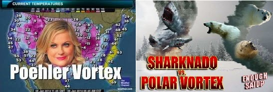 |
| 2 Of My Favorite Polar Vortex Memes |
Alright, let's do some learning. The Polar Vortex is NOT an event. It's not a thing us TV folks came up with to get your attention. It's been studied by climate scientists for decades. It was actually 1st identified in the 1800's.
 |
| Courtesy: Mashable.com. Polar Vortex winds depiction. |
Strictly speaking, this polar vortex that will dip down into the northern U.S. is the whirl of winds that flows west-to-east and encircles the North Pole over the northern hemisphere (NH). Very simply, the STRONGER these winds run, the COLDER they get, and the more efficient they are at keeping the Arctic-frigid air around the poles.
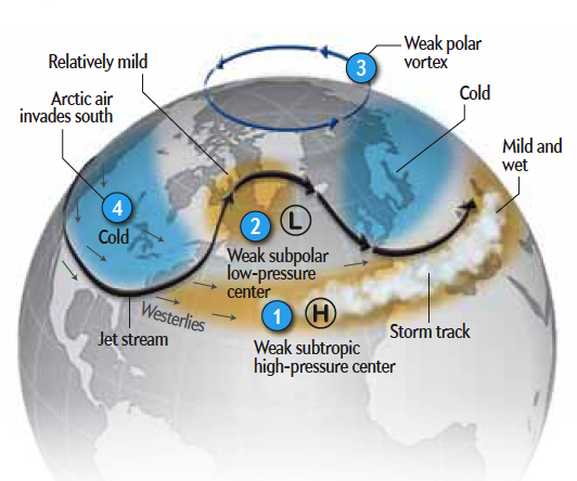 |
| Courtesy: scientificamerican. General upper air patter during a Weak Polar Vortex |
But... let's say these strong winds weaken... which they do from time-to-time for various reasons. When winds start to slow down, the vortex starts to waver. This in turn allows the Arctic air to break south and flow (advect) into lower latitudes while also churning warmer air from the south toward the North Pole.
Last winter was classified as a WEAK polar vortex season due to the fact these 'dips' occurred much more frequently. This allowed for a record-cold winter AND in turn resulted in record snowfall due to frequent arctic air outbreaks traveling over an 'open' Lake Michigan... resulting in more frequent lake effect snow events. The unofficial total for South Bend's snowfall last winter was 109.2 inches. Remember, it was unofficial due to missing airport data. Here's a complete look back from the National Weather Service on last winter for SBN & Fort Wayne: http://www.crh.noaa.gov/iwx/?n=2013_2014winter
More things to take out of this: the is not just 'A' polar vortex. There are two forever cyclonically rotating around Earth. They are flowing way high up in the atmosphere... almost completely free of friction to stop it. Our more familiar one over the North Pole and a second over the South Pole. There's also a polar vortex over the north pole of Saturn AND the south pole of Saturn... and Jupiter... and Neptune... and every planet. The only rule is that the plant needs an atmosphere. No wind... no polar vortex. Very simply again, it is just caused by the planet balancing out the heat budget from the equator to the poles of the planet... it's totally a normal thing. It's not weird.
 |
Courtesy NASA.gov: NASA's Cassini Spacecraft Obtains Best Views of Saturn Hexagon 'Polar Vortex'
|
So there you have it. An overused term that brought memes, the 'Winter Misery Index' and countless misrepresentations. I guess, here we go again. The polar vortex will soon weaken this week... leading to Michiana temps only in the low to mid 30s for highs and lows in the 20s. This may even lead to some lake effect snow flurries and showers. Here's our extended forecast: http://www.fox28.com/weather
Stay warm & stay safe,
Joe
Subscribe to:
Posts (Atom)